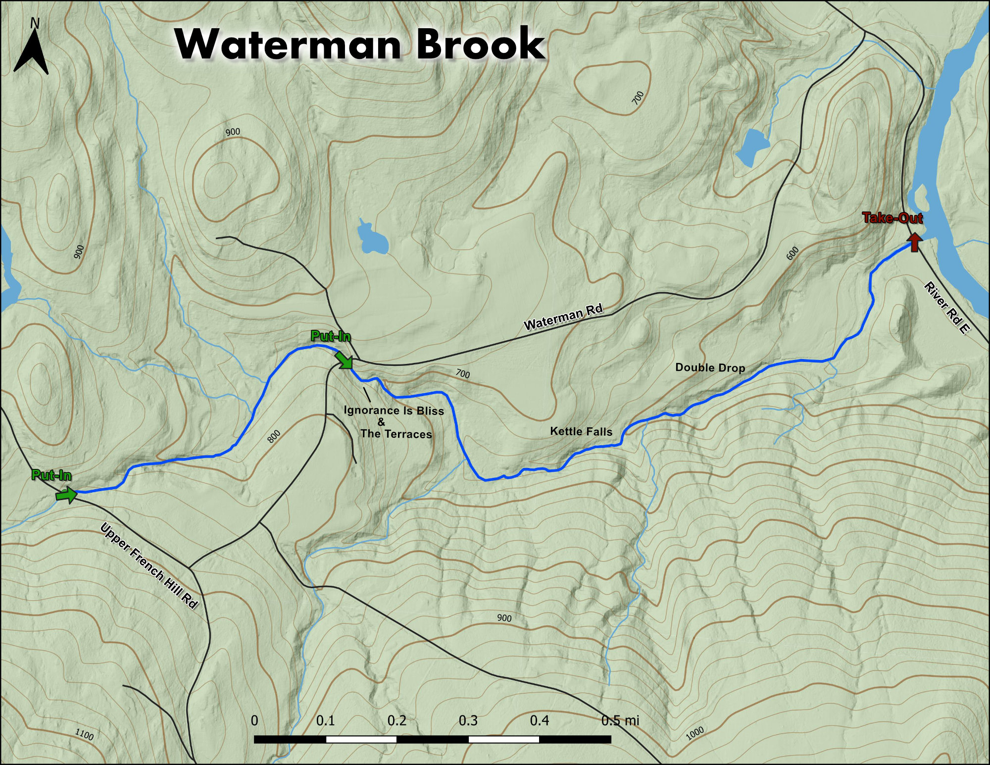
Waterman Brook

The Stats


Location:
Johnson
Length:
1.55 miles (from Upper French Hill Rd)
Class:
IV+
Flow Direction:
Northeast

Starting Elevation:
850′

Ending Elevation:
525′

Average Gradient:
210′ / mile

Rapid Type:
Bedrock ledges and falls

River Grade:  B


Waterman Brook traverses the back hills of Johnson Vermont, cascading over and through a collection of secluded bedrock ledges and falls before meeting the Lamoille River just above town.  Though it will never be as popular as its bigger cousin the Gihon, it is well worth a visit when water levels in the area are high.  For a great day of micro-creeking combine a run on Waterman with neighboring Kenfield and Sterling Brooks, known as the Sterling Range trifecta.

Eric Sorenson profile picture Vermont Whitewater Kayaking

Meet Your Local Guide:

 
Eric Sorensen


Backyard run takes on a literal meaning when used to describe what Waterman Brook is to Eric.  With the creek flowing within steps of his home you simply cannot get more local.


Homebase: Johnson, VT


Local Runs:  Waterman Brook | The Kenfield (Terril Gorge)


Favorite VT River: Ridley Brook
Favorite VT Rapid:  Mustang – Gihon River
Favorite Run Outside VT:  Upper Youghiogheny, MD

Put-In

From the take-out backtrack to Waterman Rd.  Follow this upstream to one of two put-in options.  For lower water / bang for your buck, put in at the first bridge across the stream.  When the water is higher the upper section adds some fun.  Continue up Waterman Rd to Upper French Hill Rd.  Take a right here and put in at the bridge (this is one of three tributaries so it will be very small here).

Take-Out

From Johnson take Railroad St south across the Lamoille and turn left immediately after the bridge onto River Rd E.  Follow this up the Lamoille for a little over a mile until you hit Waterman Rd.  Continue a short distance past here to the small bridge and parking / fishing access area.

FLOW INFO

Online Gauge:
Ranch Brook At Ranch Camp, Near Stowe, VT


Flow Range:
80 – 190


Visual Gauge:
River Left Wall of River Rd E Bridge @ the Takeout

Left image shows the creek upstream of the takeout at a medium-low level.  Right image shows the gauge when the creek is not running.

**Warning,
if the Lamoille is very high, the backwater may flood underneath the bridge and affect the gauge reading.  You can also look at the creek under the Waterman Rd bridge, but be aware the drops just downstream here are the first to close out at higher flows, so the rest of the run may still be good even if it looks too high to paddle here.

Flow Range:
1 to 1.5 : Low
1.5 to 2.5: Medium
3+: High

The Run

Description: E Sorenson | Photos: S Gilbert

SAFETY NOTES:

Careful when arriving at the Waterman Rd bridge (lower put-in).  The next rapid, known as Ignorance Is Bliss see photo,  is considered a portage as it flows directly into a major undercut.  It has only seen one known run.

Eric Sorenson running a rapid on Waterman Brook Vermont Whitewater Kayaking
Eric S on the tight section below Upper French Hill Rd

The snow and rain that falls on the north east side of Whiteface Mountain eventually comes together to form Waterman Brook. Though it can be somewhat elusive it does run when other runs in the area are at a good flow.

Look for Waterman to come in when the Gihon is on the rise or above 4 feet (at which point the Gihon can be quite spicy for most paddlers). Being less than 10 minutes up the road, in such a situation Waterman is worth a look.

Eric Sorenson on his backyard creek Waterman Brook Vermont Whitewater Kayaking
Eric S in the constricted ledge after the portage
Adam Putnam runs The Terraces Rapid on Waterman Brook Vermont Whitewater Kayaking
Adam P in the Terraces

Waterman can be thought of in two sections.  The upper from Upper French Hill Rd to Waterman Rd is very small featuring a handful of tight drops that only come in with higher water.  The lower from Waterman Rd down is the most commonly paddled section.  Be careful as the lower section begins with a portage around a nasty rapid that flows into a severely undercut wall / pocket.

It is a true “ bed rock run” featuring numerous class IV and V slides and “pothole” waterfalls. Two of which are in the 10 foot plus vertical drop range.

As it makes its way through the backwoods of Vermont the scenery is top notch the entire way.

Eric Sorenson drops Kettle Falls Waterman Brook Vermont Whitewater Kayaking
Eric S drops Kettle Falls
Eric Sorenson flys off Double Drop Waterman Brook Vermont Whitewater Kayaking
Eric S flying off Double Drop

If trying to catch waterman it is best to set your sights during the peak of the northern Vermont snow melt season. If you can float a boat easily through the culvert pipe at the put in then you are good to go and the run will increase in volume and excitement as you go. 

Stepping Stones

Creek VT river guide coming soon
Not quite ready for Waterman? Kenfield Brook is a touch easier and only 10 minutes away.
Guide to the Green River Vermont Whitewater Kayaking
If you like Waterman you're sure to love the Green.
Ridley Brook guide Vermont Whitewater Kayaking
Looking for more? Ridley Brook is a great next step.