Patterson (Upper White River)

The Stats

Location:
Granville
Length:
1.20 miles
Class:
IV-
Flow Direction:
South East

Starting Elevation:
1235′

Ending Elevation:
975′

Average Gradient:
218′ / mile

Rapid Type:
Small Ledges, Slides and Boulder Rapids

Put in:
(-72.86665, 43.9937)

Take Out:
(-72.84881, 43.98519)

River Grade:  A


Pristine water, beautiful surroundings, clean ledges and slides make this run a creek boating paradise for a wide range of paddlers.  Those cutting their teeth will love lower flows, where they can practice in a fun and challenging but relatively safe environment.  Seasoned veterans will find delight in an exciting high-water romp.  Patterson Brook is a true hidden gem. 

Profile picture of Mike McDonnell Vermont Whitewater Kayaking

Meet Your Local Guide:

 
Mike McDonnell


Mike wisely settled down in a location central to some fantastic boating. Soft spoken and super friendly, his demeanor belies the fact he is competent and comfortable on wilderness class V and has some wild stories to tell. Despite this Mike seems just as happy and at home on a low water Patterson jaunt as a padded Middlebury run. It is this exuberance, regardless of class, conditions or companions that demonstrates his true love of the sport. Mike is a guy you are always glad to see pull into the take-out parking lot.


Homebase: Rochester, VT


Local Runs: Patterson Brook


Favorite VT River: Middlebury Gorge

Favorite VT Rapid: Tester – Middlebury

Favorite Run Outside VT: Taureau (Jacques-Cartier), QC

Put-In

Use the small pull off just below Patterson Brook Road.  You can also continue as far up the stream as desired more fun if the water is high.

Take-Out

Use the small pull off by the building across from the defunct bridge.  This is private property but they have been very friendly towards boaters.  Please act accordingly.

FLOW INFO

Online Gauge:
New Haven @ Brooksville
Ayers Brook @ Randolph


Flow Range:
New Haven:  900 – 3500
Ayers Brook:  250 – 800


Visual Gauge:
Rock in middle of river upstream of defunct bridge.


Flow Range:
No flow over rock: Low
Water just splashing over rock: Medium-Low
Solid flow (1″-2″) over rock: Medium
Solid flow (3″-4″) over rock: Medium-High
Solid flow (4″+) over rock: High


Top picture shows a high level, bottom picture shows a medium low level.  Gauge rock is visible in middle of the bottom image.

The Run

Description: M McDonnell | Photos: S Gilbert

Mike Mainer and Chandler Smith on Dog Leg, Patterson Brook Upper White River Vermont Whitewater Kayaking
One of the harder drops on the run - DogLeg

Spilling out from the edge of Green Mountain National Forest, there are only two things about Patterson Brook that aren’t straightforward:  its name, and knowing the water level before you arrive. The first was apparently the result of a simple map-reading mistake when whitewater pioneers probed this creek- they called it Patterson Brook , which is really the tributary stream at the put-in, and though the creek is actually the upper White River proper, the name stuck and no one had the heart to make a fuss about it.  Patterson Brook it shall remain to all who don a PFD and dip their blade(s).

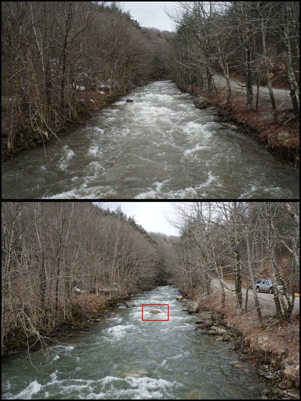
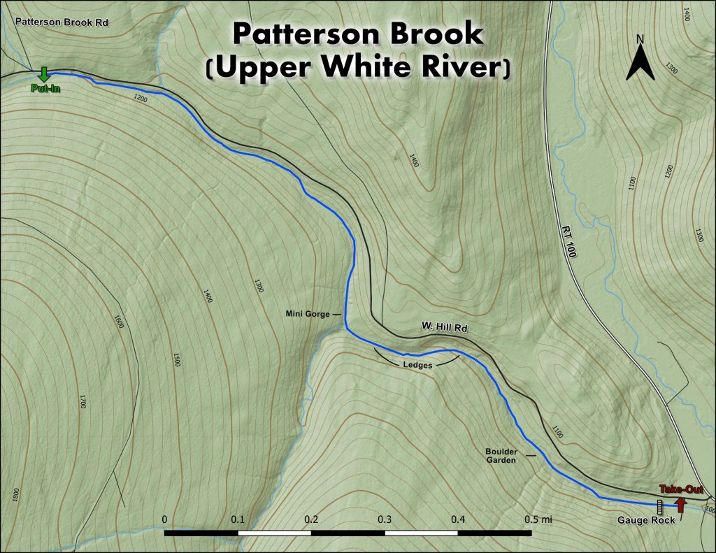
The second tricky part about Patterson- predicting the water level- has to do with observed weather data, gauge correlation and straight intuition. Experience helps but it’s not a perfect science. Generally speaking, regional water levels need to be high in order for Patterson to be running. You won’t find it running when nothing else is (thunderstorms aside).  The New Haven gauge is useful as a correlation, since their headwater areas touch, but mostly for rain events; in the spring snowmelt season, the west-facing New Haven basin soaks up the warm afternoon sun and rises predictably each evening. Nearby Patterson Brook, with its eastern exposure to weak morning sun, doesn’t come up the same way. It needs very warm spring temperatures, or warmth plus rain, to get the snow melting and the water flowing.  The Mad River gauge at Moretown can provide more clues about what is happening locally.

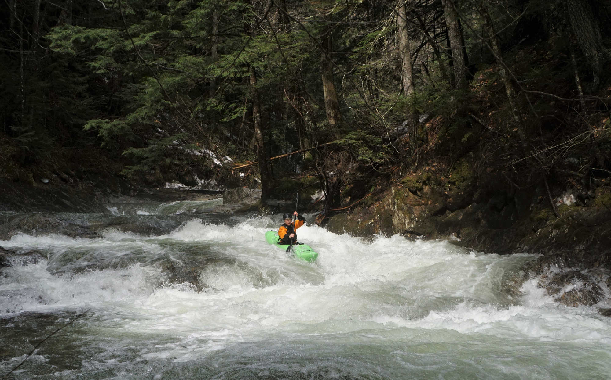
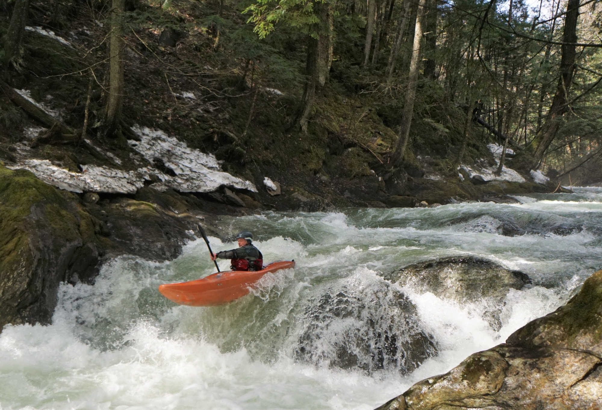
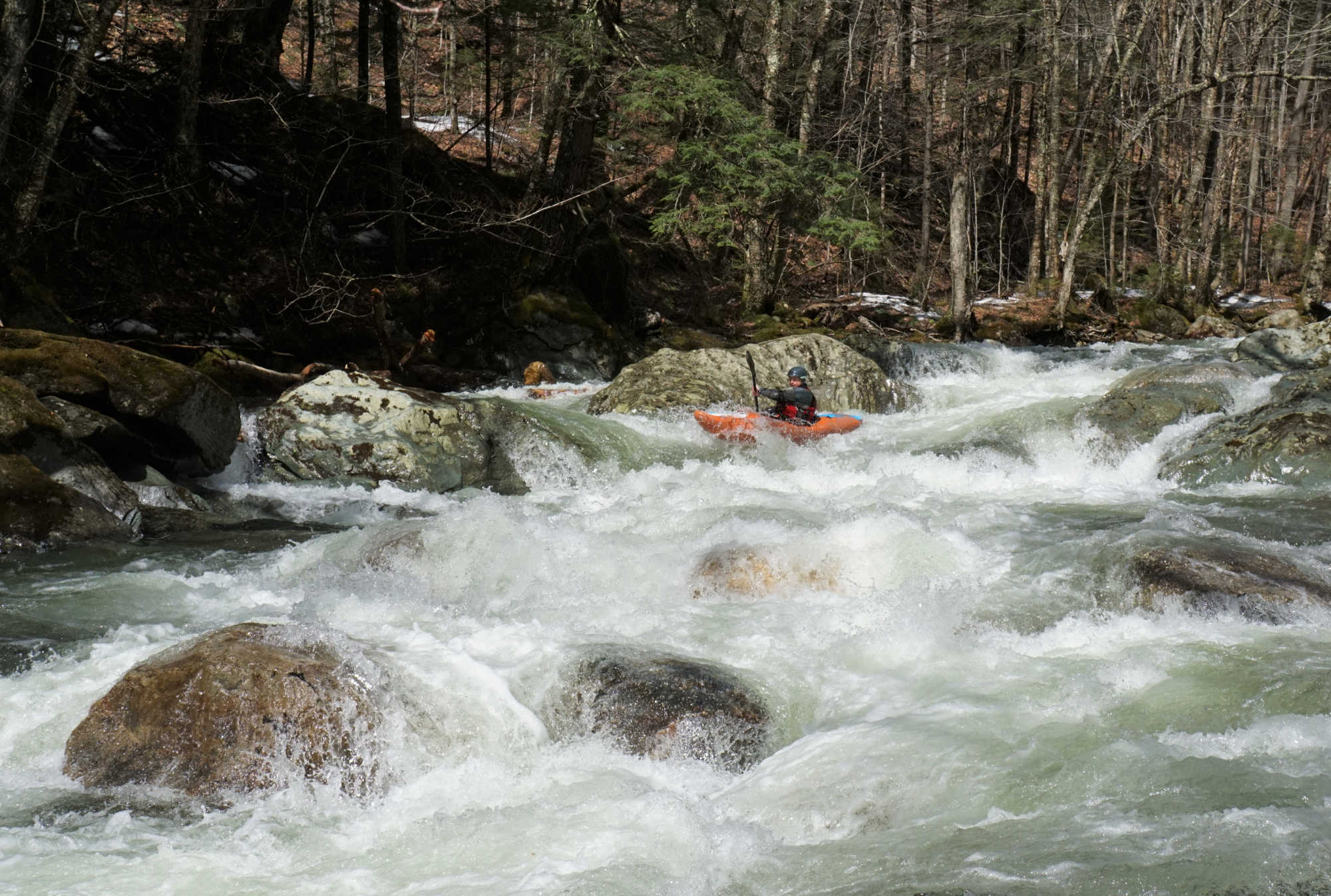
Because it is short and basically roadside, Patterson is a good step-up run for those looking to progress from river-running stuff like the Lower Mad to more technical standards like the New Haven.  Pick your day though…your crew should include some seasoned creekers who are cognizant of the water level and current wood situation.  

If you arrive and find the creek running, the rest is all downhill, more or less literally.  The takeout is mere yards from Route 100 and within sight of a general store which sells beer at privateer prices.  The unconscious part of your brain could get you from the takeout to the put-in. Drive uphill. At the fork….veer left to follow the river.  When you feel like you are at the put-in….(been driving 5mins, confluence of streams, place to turn around, place to park) you are. Suit up and commence having fun.  (Note: the second half of the shuttle, above the fork, is unplowed and used by snowmobiles in winter. If you have to drag boats in for an early spring run, it’s not a big deal.  The road is not steep and the walk gives you a chance to scout for strainers as you go.)

Chandler Smith on Patterson Brook (Upper White River) Vermont Whitewater Kayaking
Standard action on Patterson.

The typical rapid on Patterson Brook starts as class 2 or 3 whitewater in multiple channels which converge as they descend into a single class 3 or 4 pinch.  Thus, at minimum boatable flows, the water at the entrance to each rapid is likely to be spread a little too thin, but it accumulates and cleans up a bit as you funnel into the crux.  While several rapids culminate in holes, many just end in powerful seams or tongues that speed you onward toward the start of the next rapid. While trees can get hung up anywhere, be especially mindful of strainers deposited in the bottlenecks by high water- you won’t have an alternate line, so don’t get caught unaware.

Mike Mainer boofs on Patterson Brook Upper White River Vermont Whitewater Kayaking
A fun ledge into a nice pool.

From the put-in, read and run your way down the roadside section and pick your way through the brief wide, shallow stretch…really the only broad section of the river until things fall apart immediately above the takeout.   

The river bends slightly right and gathers into real rapids again, then slightly left as it approaches Volkswagen Rock, a humped midstream boulder reminiscent of a VW Beetle. Run to the left of the rock, and do your best to boof over the substantial hole under its shoulder.  This rapid’s runout is called the mini-gorge and is 30 seconds of diagonal-punching action. It abruptly ends in a dark, moss-draped glen with a beautiful waterfall cascading in from river right. You’ll look up the stair-step brook above the waterfall and wonder ‘Maybe…?’, but then you’ll realize that you are already on one of the smallest creeks you’ve ever run, and that this is a tributary.  Pipe dream!! Now where were we?

The next rapid is Dogleg, so-named for the way it jogs hard to the right and immediately doubles back to the left.  Paired with its steep, hole-studded runout, this is the toughest section on Patterson Brook. Eddy out left to scout from the prominent ledge.  Dogleg can squirt you toward any of the four points of the compass so be prepared to recover quickly and get lined up for the bottom which starts out manky and then serves up back-to-back holes…the first to rob you of speed and the second to surf you if you stall out.

Mike Mainer runs a boulder garden on Patterson Brook Upper White River Vermont Whitewater Kayaking
The boulder garden near the end of the run.

Two rapids later is a classic Patterson pinch that finishes with the run’s best boof.  Approach down the right, drive left across the flow and use a right boof stroke to soar toward an eddy-smacking landing below.  There are three or four more quality rapids, the last one an easy broad slide. Just beyond the slide, beware of a boulder-garden rapid that turns the Patterson model on its head…it starts narrow and spreads out as it descends steeply into a jumbled matrix of mid-stream boulders whose only virtue is that they are round and smooth.   Entering this minefield at high speed makes it tough to finesse…my approach here is to paddle hard and as straight as possible and go right over whatever is in front of me. Beware an end-to -end broach if you get glanced sideways in this rapid.

It’s all over.  The river begins to widen as the takeout bridge comes into view, then the gauge rock, which shows that the water level is holding.  You get to go up and do it again.

Map of the rapids on Patterson Brook Upper White River Vermont Whitewater Kayaking

Stepping Stones

Creek VT river guide coming soon
Not quite ready for the Patterson? The Lower Mad is a great place to build confidence.
Creek VT river guide coming soon
If you like Patterson, then you're sure to enjoy neighboring Bingo Brook
Guide to Gihon River Vermont Whitewater Kayaking
Looking to step it up? The Gihon will satisfy those looking for more of a challenge.